Long, straight and narrow: Grenville Channel
24-25 July 2012 Grenville Channel: Lowe Inlet Marine Provincial Park and Klewnuggit Inlet Marine Provincial Park
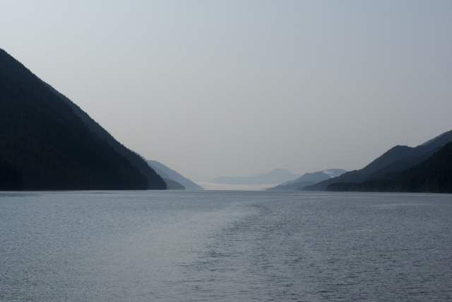
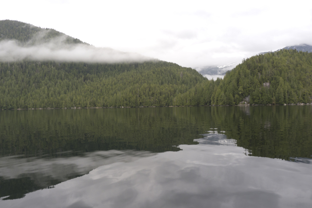
Grenville Channel is a straight narrow deep chasm that runs some 45 miles northwest from Wright Sound almost all the way to Prince Rupert, part of the Inside Passage to Alaska. So straight and so narrow (just 500-600 meters wide in places) is the channel that it seems a human-made passage, a canal, which is, indeed, how it is used by vessels both large and small. But it is also deep (deeper than 90 meters in most places) and surrounded by peaks that rise to 3500 meters; digging this groove was a glacial, not human-powered feat.
Despite all of the charts and tables and Coast Guard officers we consulted, we didn’t get the timing of the tides in Grenville Channel right. Once we turned into the channel, we slogged forward at just 2.5-3.5 knots, with both wind and current against us for hours, trying first one side of the channel and then the other to see if we could find more favourable currents. Obviously, we were still missing some important information about how to time our passage through the Channel—but what was it? Did the current change a full two or three hours after the tide?
Early on, we crossed wakes with a large cargo vessel, the MPP Triumph, and hailed the bridge to inquire about the nature of its cargo: it was bringing heavy steel from Hong Kong to the Rio Tinto Aluminum Plant at Kitimat. The Countess of Dufferin Range (yes, the wife of the same Dufferin honoured in our home town of Port Dufferin, Nova Scotia, a Victorian British gentleman and one-time Governor General of Canada) rose above the eastern side of the channel, a bald-headed granite-faced moonscape of a range.

Verney Falls Lowe Inlet
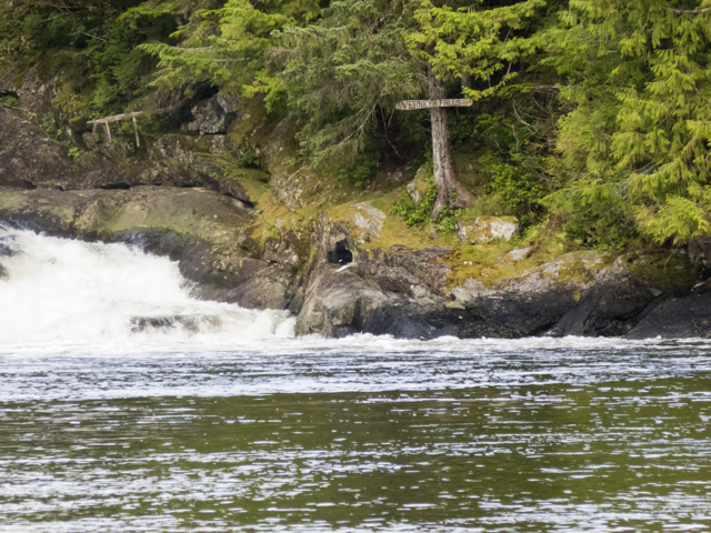
Finally we arrived at Lowe Inlet, and decided to stop there for the night. Slack tide permitted us to negotiate the narrow entrance. Suddenly we were in another world.

salmon leaping up the falls, Lowe Inlet
At one end of the inlet, a roaring falls. Salmon jumped wildly everywhere as we circled around looking for a place to anchor—they made huge whirling leaps clear of the water and then landed dorsal side to the water with an enormous smack. Overhead birds streamed and called: gulls, Bonaparte’s gulls, marbled murrelets, hawks, ravens, golden eagles, bald eagles, and their young. Scent and rush of blood in the air. We approached Verney Falls, and anchored some distance out, bow to the current, cedars arching over the water. Even the horseflies and black flies got in on the excitement, feasting on us despite the wind from the falls.

Eagles and ravens on a silver snag over the falls
Everywhere we turned we saw salmon leaping and splashing, their silvery bodies flashing up the falls, more and more of them flooding into the inlet as the tide rose and the falls became shorter.
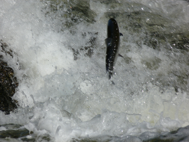
salmon leaping up Verney Falls
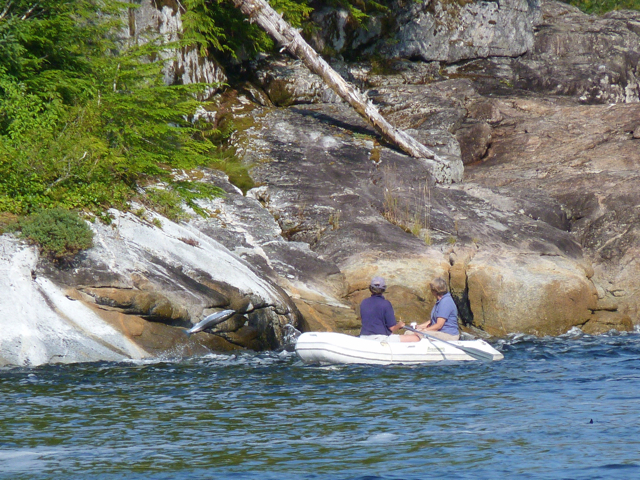
Marike decided to launch the dinghy and troll for salmon. She set up a flasher and a hoochie with two barbless hooks; Karin got the net, the shot hammer (our instrument of death) and the bucket, and climbed into the dinghy to row.
Up and back and across the outflow from the falls we went. Salmon jumped all around us. One smacked into the dinghy; we were splashed by jets of saltwater, but not a single fish bit. All we collected on our hooks were tangles of kelp when we got too close to shore.

Golden Eagle watching over the falls
What do you think the salmon are doing? Marike asked. Why are they jumping before the falls?
Practicing, Karin decided.
Marike decided she didn’t like Karin’s distracted rowing while salmon rubber-necking, so she took over and Karin trolled, with no better results.
Marike and Elisabeth get splashed by leaping fish
We approached the falls, and tried to net a fish, but our efforts were without issue. Near shore, one salmon jumped up and hit the bottom of the boat so hard it stopped the dinghy. We were soaked by the splash and for a moment it seemed as if we’d run aground. Not at all; we’d been salmoned.

Bear nabs a salmon, dashes up the rock
Suddenly, at eye level, a bear, stepping down into the falls, watching, watching, and then swoosh, its paw flashed in the falls and there was an enormous salmon, snagged by the gills. The bear clambered up the rocks and headed back into the cedars. Meanwhile, fins in the water, whirlpools, dark backs darting, flashes of bodies shooting up the falls, another splash next to the dingy, drenching us.

Big bear, dead fish
There, there! Marike cried, get that one! Net it!
Nope, said Karin. I’m done. Time to go back for the camera; we’re not catching any salmon this way. We’ll have better luck that way, though we can’t eat them.

Abandoned fishing weir, Lowe Inlet
Once we got the camera, another bear came, and then another and another. Later Elisabeth went to the falls too, and then Marike tried netting again, driving herself up into the falls, wedging the dinghy against the rocks as she reached around with the net. Nothing. Luckily.
For later, once we settled enough to consult our guide to the fishing regulations, we realized that we were not in a legal fishing zone: “Area 5. All finfish including salmon. Inside a line drawn from fishing boundary signs located approximately 100 meters seaward of the falls at the mouth of the Kumowdah River flowing into Lowe Inlet, is closed to fishing for all finfish July 1- October 31.” Whoops. So that’s what those triangular signs meant. Novice fishermen are a confused lot. Now we get it—we were in a BC Marine Park. And First Nations territorial waters. And the Kumowdah River is an important spawning grounds. No fishing by humans allowed.

Verney Falls, evening
As we watched the drama at the falls, we noticed that the large male bears fished from the left side of the falls, where it was easier to stand out on the top of a rock and reach into the water, while females seemed to fish the right side, where they had to drop down a series of rocks and stand in the flow to catch a salmon.
Cub with salmon on rock
At one point, a small cub emerged from the woods, its mother behind it. Mother pushed the small bear forward, but the little one didn’t want to get her paws wet.
No wet paws, no dinner. Reluctantly, slowly, the little one went and stood in the water. In time, she noticed the fish leaping all around her. Finally she swiped a paw in the water. Nothing. Another swipe. Nothing. She lifted her paws from the water, shook them, and looked around miserably.
Suddenly she saw a fish, ducked her head in the water, and nabbed the salmon in her teeth. It writhed and flopped as the little bear climbed up the rocks, and managed to get away. Little bear went back down into the flow, tried again and again. Each time she caught a fish in her teeth, the fish managed to wriggle away. The mother bear slipped out of the trees to check on her cub, then melted back into the woods: things were proceeding as they should.
Finally the little cub managed to catch a smaller fish. She scrambled up the slope to a flat grassy area, killed and ate her fish. Victory! Thus heartened, she returned to the water for another try. This time she got her fish more quickly, leaped up the rock, and feasted on her prize.
The third catch was a little different. She took the fish to the grassy place, then sat down beside it. She didn’t eat right away, but put her paw on the fish and looked around proudly, as if to say, “I am a fishing bear! I can catch all the fish I want and need.” The eagles and ravens watched her, then one bald eagle descended and approached the cub. The two animals, bird and bear, made some sort of entente, and then together picked away at the fish, sharing this abundance.

salmon carving
We felt that we finally understood what Alexandra Morton meant when she said that the salmon were the lifeblood of the coast. We had finally witnessed the salmon forest in operation—as the salmon raced back up the rivers to spawn, some of them fed birds and other animals, who then carted the remains of the salmon deep into the forest, fertilizing the enormous trees and plant life of the rain forest. The decaying carcases of the salmon also nourished their own young, and made the rivers rich flows of nutrients for all sorts of other life. Truly, as the Coast Salish carving of a salmon we’d hung near the galley in the boat promised, a dwelling that contains a salmon is a place where no one goes hungry.

Anchored in Klewnuggit Marine Provincial Park
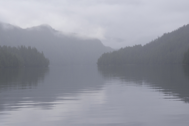
Sailmail that evening delivered two pieces of news that tugged at us. One was celebratory: our niece Katie and her husband David had just welcomed a healthy new 8 lb baby—Bobby–into the world. The other item was sobering; Karin had been appointed to the selection committee for the new president of NSCAD (Nova Scotia College of Art and Design), and the first meetings were already scheduled. She would have to get back before the end of August. We had hoped to make Prince Rupert, but now it seemed prudent to turn back soon. Klewnuggit, the next harbour off of the Grenville Channel, would be our last forward harbour—we’d have just one more day before we turned back “to the stable,” the airport, and Nova Scotia.
Fog drifts into Klewnuggit
We learned, the hard way, that the flow of the tide did not split at Lowe Inlet, but rather near Klewnuggit, another provincial marine park. Jagged reefs guarded its entrance, and towering peaks covered in perpetual snow fields carved the sky into sharp angles. The water was deep and green.

Reflection, Klewnuggit
At the foot of the East Inlet, a stream tumbled through cedars and across granite boulders. Mudslides everywhere down the steep slopes and stripes of white like the lines of a musical score, marked where the various tides habitually stopped.

lines like a musical staff
We watched the clouds move in as the evening fell, our mood a bit gloomy. No one wanted to turn around yet; we were just getting going.
Still, we were also proud. We had nearly made it to the boundary between BC and Alaska. The coast of British Columbia with all of its inlets and the fine company had been too wonderful to rush any faster. Next year, we would make Alaska.
Klewnuggit in fog
Notes
Lowe Inlet Marine Provincial Park http://www.env.gov.bc.ca/bcparks/explore/parkpgs/lowe_inlet/
Klewnuggit Inlet Marine Provincial Park http://www.env.gov.bc.ca/bcparks/explore/parkpgs/klewnuggit_inlet/

Felicity Free–was entertained by the discription of your visit to Lowe Inlet and Verny Falls. We very much enjoyed frolicking with the leaping salmon. One of my crew even had the dubious pleasure of swimming with the salmon after the intrepid adventurer investigated the falls outflow a bit to closely.
It was nice to meet up with you at West Beach in Pruth Bay.
Felicity Free is presently on the hard in Shelter Island. I’m in Saint John now savouring the memories of my 15 week adventure up the northern coast of BC and looking forward to 2014.
Mark
Hi there Mark & Felicity Free. It was a pleasure to meet you and crew in Pruth Bay. We’ve been a bit quiet here–had a bit of a tragedy that befell us–a jackstand crumpled under the boat and she was blown over in a wind storm. We thought we’d have to write her off but it seems that she’s going to be able to be repaired. We’ll have news on that front shortly. Meanwhile, a few scary moments: Yikes! But we are again looking forward to being back on the water in BC in July.
“Sorry to hear about Quoddys Run. It must have been very disheartening to receive that call. I’m pleased that she will be back in the water again for this summer. Felicity Free is on the hard at Shelter Island patiently awaiting my return hopefully by the end of March. Trying to put together a plan for this year. Contemplating 2 options, a slow trip around the west coast of Vancouver Island or an equally relaxed passage up to Haida Gwaii. Look forward to meeting up again during our Adventures. Will keep an eye on your blog for updates.